
Make a donation
Gear up for your next adventure:
As an Amazon Associate, this site earns from qualifying purchases at no extra cost to you.
Timmenrode topographic map
Click on the map to display elevation.
Make a donation
Gear up for your next adventure:
As an Amazon Associate, this site earns from qualifying purchases at no extra cost to you.
About this map
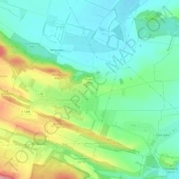
Name: Timmenrode topographic map, elevation, terrain.
Average elevation: 191 m
Minimum elevation: 148 m
Maximum elevation: 279 m
Make a donation
Gear up for your next adventure:
As an Amazon Associate, this site earns from qualifying purchases at no extra cost to you.
Other topographic maps
Click on a map to view its topography, its elevation and its terrain.
Ziegenkopf
Deutschland > Sachsen-Anhalt > Landkreis Harz > Blankenburg
Vor über 100 Jahren wurde auf der Bergkuppe des Ziegenkopfs der steinerne und im oberen Teil mit Holz verkleidete Aussichtsturm Ziegenkopfturm mit 30 m Höhe errichtet, der eine gute Rundumsicht bis hin zum Brocken bietet. Direkt an den Turm angegliedert ist der Berggasthof Ziegenkopf.
Average elevation: 331 m
Make a donation
Gear up for your next adventure:
As an Amazon Associate, this site earns from qualifying purchases at no extra cost to you.