
Yala National Park topographic map
Interactive map
Click on the map to display elevation.
Yala National Park
The Yala area is mostly composed of metamorphic rock belonging to the Precambrian era and classified into two series, Vijayan series and Highland series. Reddish brown soil and low humic grey soil are prominent among six soil types. Yala is situated in the lowest peneplain of Sri Lanka, which extends from Trincomalee to Hambantota. Topographically the area is a flat and mildly undulating plain that runs to the coast with elevation is 30 metres (98 ft) close to the coast while rising in the interior to 100–125 metres (328–410 ft). The national park is situated in the dry semi-arid climatic region and rain is received mainly during the northeast monsoon. The mean annual rainfall ranges between 500–775 millimetres (19.7–30.5 in) while the mean temperature ranges between 26.4 °C (79.5 °F) in January to 30 °C (86 °F) in April. It is windier in Yala, during the southwest monsoon compared to the wind during the northeast monsoon with wind speeds from 23 kilometres per hour (14 mph) to 15 kilometres per hour (9.3 mph).
About this map
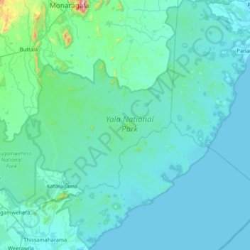
Name: Yala National Park topographic map, elevation, terrain.
Average elevation: 67 m
Minimum elevation: -1 m
Maximum elevation: 1,096 m
Other topographic maps
Click on a map to view its topography, its elevation and its terrain.