
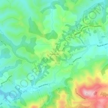
Paxkoenea topographic map
Interactive map
Click on the map to display elevation.
About this map
Name: Paxkoenea topographic map, elevation, terrain.
Average elevation: 135 m
Minimum elevation: 48 m
Maximum elevation: 338 m
Other topographic maps
Click on a map to view its topography, its elevation and its terrain.
Ermindegi
France > Nouvelle-Aquitaine > Pyrénées-Atlantiques > Hasparren
Ermindegi, Hasparren, Bayonne, Pyrénées-Atlantiques, Nouvelle-Aquitaine, France métropolitaine, 64240, France
Average elevation: 119 m
Zelai
France > Nouvelle-Aquitaine > Pyrénées-Atlantiques > Hasparren
Zelai, Hasparren, Bayonne, Pyrénées-Atlantiques, Nouvelle-Aquitaine, France métropolitaine, 64240, France
Average elevation: 207 m
Hazketa
France > Nouvelle-Aquitaine > Pyrénées-Atlantiques > Hasparren
Hazketa, Hasparren, Bayonne, Pyrénées-Atlantiques, Nouvelle-Aquitaine, France métropolitaine, 64240, France
Average elevation: 98 m