
Make a donation
Gear up for your next adventure:
As an Amazon Associate, this site earns from qualifying purchases at no extra cost to you.
Vicuña topographic map
Click on the map to display elevation.
Make a donation
Gear up for your next adventure:
As an Amazon Associate, this site earns from qualifying purchases at no extra cost to you.
Vicuña
The area is dominated by a mountainous backdrop, and extensive plains on the valley floor, where high-quality grapes for pisco are grown, along with other fruits and vegetables. The La Punilla, Atimonate, Balalita, Los Tilos mountain ranges contain several peaks with altitudes over 4,000 m.
Make a donation
Gear up for your next adventure:
As an Amazon Associate, this site earns from qualifying purchases at no extra cost to you.
About this map
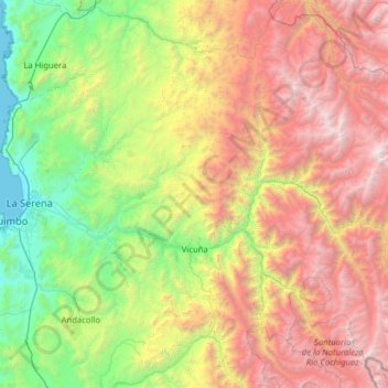
Name: Vicuña topographic map, elevation, terrain.
Average elevation: 1,973 m
Minimum elevation: 0 m
Maximum elevation: 5,623 m
Make a donation
Gear up for your next adventure:
As an Amazon Associate, this site earns from qualifying purchases at no extra cost to you.
Other topographic maps
Click on a map to view its topography, its elevation and its terrain.