
Make a donation
Gear up for your next adventure:
As an Amazon Associate, this site earns from qualifying purchases at no extra cost to you.
Aidlingen topographic map
Click on the map to display elevation.
Make a donation
Gear up for your next adventure:
As an Amazon Associate, this site earns from qualifying purchases at no extra cost to you.
Aidlingen
The municipality (Gemeinde) of Aidlingen is found in the district of Böblingen, in the German state of Baden-Württemberg. Aidlingen lies on the western edge of Böblingen district, along its border with Calw's district, and physically in the Heckengäu and the Upper Gäu [de] regions. The main watercourse in the municipal area is the Würm, which flows north-to-west through the eastern portion of the municipality. The lowest elevation above sea level in the municipal area, 403 meters (1,322 ft) Normalnull (NN), is found along the Würm. The highest, 576 meters (1,890 ft) NN, is near Dachtal.
Make a donation
Gear up for your next adventure:
As an Amazon Associate, this site earns from qualifying purchases at no extra cost to you.
About this map
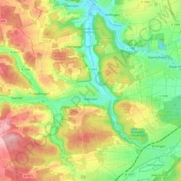
Name: Aidlingen topographic map, elevation, terrain.
Average elevation: 481 m
Minimum elevation: 399 m
Maximum elevation: 580 m
Make a donation
Gear up for your next adventure:
As an Amazon Associate, this site earns from qualifying purchases at no extra cost to you.
Other topographic maps
Click on a map to view its topography, its elevation and its terrain.
Merklingen
Germany > Baden-Württemberg > Landkreis Böblingen > Weil der Stadt
Average elevation: 436 m