
Make a donation
Gear up for your next adventure:
As an Amazon Associate, this site earns from qualifying purchases at no extra cost to you.
Tarbela Dam topographic map
Click on the map to display elevation.
Make a donation
Gear up for your next adventure:
As an Amazon Associate, this site earns from qualifying purchases at no extra cost to you.
Tarbela Dam
Tarbela Reservoir is 80.5 kilometres (50.0 mi) long, with a surface area of 250 square kilometres (97 sq mi). The reservoir initially stored 11,600,000 acre-feet (14.3 km3) of water, with a live storage of 9,700,000 acre-feet (12.0 km3), though this figure has been reduced over the subsequent 35 years of operation to 6,800,000 acre-feet (8.4 km3) due to silting. The maximum elevation of the reservoir is 1,550 ft (470 m) above MSL and the minimum operating elevation is 1,392 ft (424 m) above MSL. The catchment area upriver of the Tarbela Dam is spread over 168,000 square kilometres (65,000 sq mi) of land largely supplemented by snow and glacier melt from the southern slopes of the Himalayas. There are two main Indus River tributaries upstream of the Tarbela Dam. These are the Shyok River, joining near Skardu, and the Siran River near Tarbela.
Make a donation
Gear up for your next adventure:
As an Amazon Associate, this site earns from qualifying purchases at no extra cost to you.
About this map
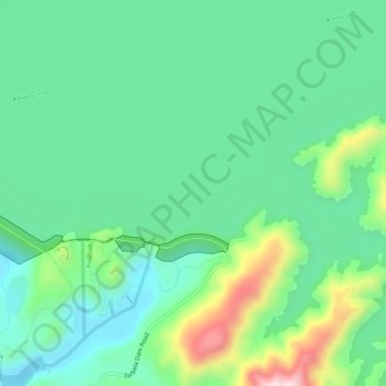
Name: Tarbela Dam topographic map, elevation, terrain.
Average elevation: 451 m
Minimum elevation: 333 m
Maximum elevation: 760 m
Make a donation
Gear up for your next adventure:
As an Amazon Associate, this site earns from qualifying purchases at no extra cost to you.
Other topographic maps
Click on a map to view its topography, its elevation and its terrain.
Make a donation
Gear up for your next adventure:
As an Amazon Associate, this site earns from qualifying purchases at no extra cost to you.
Make a donation
Gear up for your next adventure:
As an Amazon Associate, this site earns from qualifying purchases at no extra cost to you.