Geolocate

Maypole topographic map

Click on the map to display elevation.

About this map

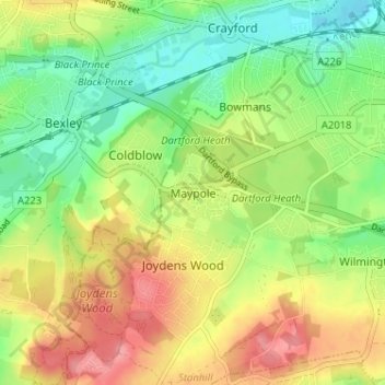
Name: Maypole topographic map, elevation, terrain.

Location: Maypole, Dartford, Kent, England, DA2 7WA, United Kingdom (51.41437 0.15212 51.45437 0.19212)

Average elevation: 39 m

Minimum elevation: 1 m

Maximum elevation: 83 m

Kent trails, hiking, mountain biking, running and outdoor activities

Other topographic maps

Click on a map to view its topography, its elevation and its terrain.

Wilmington

United Kingdom > England > Kent > Dartford > Wilmington

Average elevation: 47 m

Craylands Gorge

United Kingdom > England > Kent > Dartford > Swanscombe

Average elevation: 19 m

Bean

United Kingdom > England > Kent > Dartford > Bean

Average elevation: 52 m

Dartford Marshes

United Kingdom > England > Kent > Dartford

Average elevation: 4 m

Darenth

United Kingdom > England > Kent > Dartford > Darenth

Average elevation: 40 m

Wilmington

United Kingdom > England > Kent > Dartford > Wilmington

Average elevation: 47 m

Gear up for your next adventure:

🗺️Scratch-off Peak Maps - Track your progress climbing Munros or Wainwrights
🚲Bikepacking Frame Bags - Storage for tools and navigation gear on long off-road rides
🧺Microfibre Travel Towels - Fast-drying and compact towels for wild swimming and camping
🛌Insulated Sleeping Mats - Crucial thermal protection when sleeping on cold, uneven ground
📱Rugged Phone Cases - Heavy-duty protection for smartphones used as secondary GPS tools

As an Amazon Associate, this site earns from qualifying purchases at no extra cost to you.