Geolocate

Galia topographic map

Click on the map to display elevation.

Galia

It lies at an altitude of 250 metres (820 ft), surrounded by hills. It commands an imposing view south to the Messara Plain and to the Asterousia mountain range, west to the Libyan Sea and north to the Psiloritis mountain. It has 833 residents (2021), mainly farmers.

Wikipedia (CC-BY-SA 3.0)

About this map

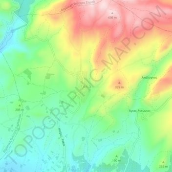
Name: Galia topographic map, elevation, terrain.

Location: Galia, Mires Municipal Unit, Municipality of Festos, Heraklion Regional Unit, Region of Crete, Greece (35.05764 24.85064 35.09764 24.89064)

Average elevation: 227 m

Minimum elevation: 88 m

Maximum elevation: 436 m

Gear up for your next adventure:

🧺Mesh Stuff Sacks - Breathable storage for wet gear or camp organization
🚶Walking Pedometers - Simple distance tracking for casual trail walkers
🧢Thermal Beanie Hats - Prevent heat loss from the head in windy summit conditions
📦Dry Bags - Waterproof bags to protect gear from rain
📐Altimeters & Barometers - Tools for measuring altitude and air pressure

As an Amazon Associate, this site earns from qualifying purchases at no extra cost to you.