
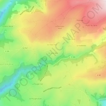
Le Viala-Bas topographic map
Interactive map
Click on the map to display elevation.
About this map
Name: Le Viala-Bas topographic map, elevation, terrain.
Average elevation: 980 m
Minimum elevation: 753 m
Maximum elevation: 1,210 m
Other topographic maps
Click on a map to view its topography, its elevation and its terrain.
Salgues Hautes
France > Occitanie > Aveyron > Condom-d'Aubrac
Salgues Hautes, Condom-d'Aubrac, Rodez, Aveyron, Occitanie, France métropolitaine, 12470, France
Average elevation: 794 m
Le Teil
France > Occitanie > Aveyron > Condom-d'Aubrac
Le Teil, Condom-d'Aubrac, Rodez, Aveyron, Occitanie, France métropolitaine, 12470, France
Average elevation: 934 m
Le Viala-Haut
France > Occitanie > Aveyron > Condom-d'Aubrac
Le Viala-Haut, Condom-d'Aubrac, Rodez, Aveyron, Occitanie, France métropolitaine, 12470, France
Average elevation: 986 m