
Rila mountain range topographic map
Interactive map
Click on the map to display elevation.
Rila mountain range
Rila (Bulgarian: Рила, pronounced [ˈriɫɐ]) is the highest mountain range of Bulgaria, the Balkan Peninsula and Southeast Europe. It is situated in southwestern Bulgaria and forms part of the Rila–Rhodope Massif. The highest summit is Musala at an elevation of 2,925 m which makes Rila the sixth highest mountain range in Europe after the Caucasus, the Alps, Sierra Nevada, the Pyrenees and Mount Etna, and the highest one between the Alps and the Caucasus. It spans a territory of 2,629 km2 with an average elevation of 1487 m. The mountain is believed to have been named after the river of the same name, which comes from the Old Bulgarian verb "рыти" meaning "to grub".
About this map
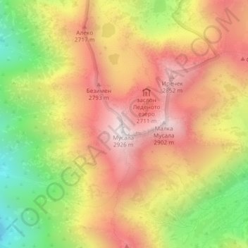
Name: Rila mountain range topographic map, elevation, terrain.
Location: Rila mountain range, Samokov, Sofia, Bulgaria (42.17995 23.58530 42.18005 23.58540)
Average elevation: 2,525 m
Minimum elevation: 2,027 m
Maximum elevation: 2,921 m