Geolocate

Cooper Point topographic map

Click on the map to display elevation.

About this map

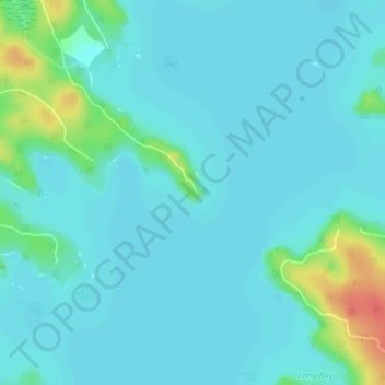
Name: Cooper Point topographic map, elevation, terrain.

Location: Cooper Point, Muskoka Lakes Township, District Municipality of Muskoka, Muskoka District, Central Ontario, Ontario, Canada (45.05343 -79.53916 45.05353 -79.53906)

Average elevation: 230 m

Minimum elevation: 221 m

Maximum elevation: 272 m

Other topographic maps

Click on a map to view its topography, its elevation and its terrain.

Gear up for your next adventure:

👕Technical Hiking Tees - Moisture-management for high-exertion climbs
🧭Orienteering Compasses - Accurate compasses for map-based navigation
🩹Hiking First Aid Kits - Compact medical kits tailored for trail injuries and emergencies
🧥Softshell Jackets - Breathable jackets for active outdoor use
💧Hydration Reservoirs - Convenient water bladders for hands-free drinking on the move

As an Amazon Associate, this site earns from qualifying purchases at no extra cost to you.