
Ga-Segonyana Local Municipality topographic map
Interactive map
Click on the map to display elevation.
About this map
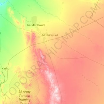
Name: Ga-Segonyana Local Municipality topographic map, elevation, terrain.
Average elevation: 1,367 m
Minimum elevation: 1,022 m
Maximum elevation: 1,856 m
Other topographic maps
Click on a map to view its topography, its elevation and its terrain.
Kathu
South Africa > Northern Cape > John Taolo Gaetsewe District Municipality > Gamagara Local Municipality
Kathu, Gamagara Local Municipality, John Taolo Gaetsewe District Municipality, Northern Cape, 8446, South Africa
Average elevation: 1,223 m