
Thank you for supporting this site ❤️
Make a donation
Make a donation
Gear up for your next adventure:
As an Amazon Associate, this site earns from qualifying purchases at no extra cost to you.
Sigowet topographic map
Click on the map to display elevation.
Thank you for supporting this site ❤️
Make a donation
Make a donation
Gear up for your next adventure:
As an Amazon Associate, this site earns from qualifying purchases at no extra cost to you.
About this map
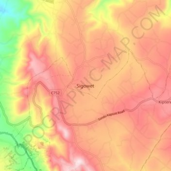
Name: Sigowet topographic map, elevation, terrain.
Location: Sigowet, Sigowet/Soin, Kericho County, Kenya (-0.43240 35.02256 -0.35240 35.10256)
Average elevation: 1,713 m
Minimum elevation: 1,397 m
Maximum elevation: 1,906 m
Thank you for supporting this site ❤️
Make a donation
Make a donation
Gear up for your next adventure:
As an Amazon Associate, this site earns from qualifying purchases at no extra cost to you.