
Balsall topographic map
Interactive map
Click on the map to display elevation.
About this map
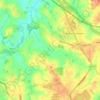
Name: Balsall topographic map, elevation, terrain.
Average elevation: 114 m
Minimum elevation: 88 m
Maximum elevation: 141 m
Other topographic maps
Click on a map to view its topography, its elevation and its terrain.
Meriden
United Kingdom > England > Solihull
Meriden, Solihull, West Midlands Combined Authority, West Midlands, England, United Kingdom
Average elevation: 137 m
Catherine-de-Barnes
United Kingdom > England > Solihull > Catherine-de-Barnes
Catherine-de-Barnes, Hampton in Arden, Solihull, West Midlands Combined Authority, West Midlands, England, B91 2TP, United Kingdom
Average elevation: 114 m
Illshaw Heath
United Kingdom > England > Solihull > Illshaw Heath
Illshaw Heath, Solihull, West Midlands Combined Authority, West Midlands, England, B94 6RU, United Kingdom
Average elevation: 139 m
Bickenhill and Marston Green
United Kingdom > England > Solihull
Bickenhill and Marston Green, Solihull, West Midlands Combined Authority, West Midlands, England, United Kingdom
Average elevation: 100 m