
Make a donation
Gear up for your next adventure:
As an Amazon Associate, this site earns from qualifying purchases at no extra cost to you.
Lappland topographic map
Click on the map to display elevation.
Make a donation
Gear up for your next adventure:
As an Amazon Associate, this site earns from qualifying purchases at no extra cost to you.
About this map
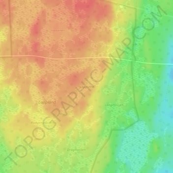
Name: Lappland topographic map, elevation, terrain.
Location: Lappland, Skinnskattebergs kommun, Västmanland County, Sweden (59.79234 15.75588 59.80136 15.78160)
Average elevation: 136 m
Minimum elevation: 104 m
Maximum elevation: 155 m
Make a donation
Gear up for your next adventure:
As an Amazon Associate, this site earns from qualifying purchases at no extra cost to you.
Other topographic maps
Click on a map to view its topography, its elevation and its terrain.
Västerås
Västerås is predominantly known as an industrial city, but also a retailing and logistics city. The city wants to distinguish itself as Västerås – Mälarstaden, meaning "Västerås—the city by Lake Mälaren", in order to attract tourists and new residents, as well as students to the local university,…
Average elevation: 28 m
Make a donation
Gear up for your next adventure:
As an Amazon Associate, this site earns from qualifying purchases at no extra cost to you.
Make a donation
Gear up for your next adventure:
As an Amazon Associate, this site earns from qualifying purchases at no extra cost to you.
Make a donation
Gear up for your next adventure:
As an Amazon Associate, this site earns from qualifying purchases at no extra cost to you.