Geolocate

Bower topographic map

Interactive map

Click on the map to display elevation.

About this map

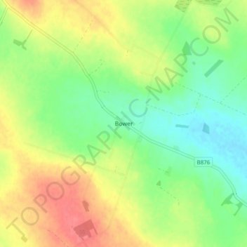
Name: Bower topographic map, elevation, terrain.

Location: Bower, Caithness, Scotland, KW1 4TN, United Kingdom (58.52688 -3.33252 58.56688 -3.29252)

Average elevation: 47 m

Minimum elevation: 20 m

Maximum elevation: 80 m

In The Standing Stones of Caithness (2003), Leslie J Myatt gives the alignment of the stones as 322 degrees, from the fallen stone to the still standing stone. This alignment may appear to suggest a summer solstice sunset which is too far north for the latitude. However, at about 75 metres (246 ft), the altitude of the stones is quite high with respect to an Atlantic horizon which is visible on this bearing. The sunset alignment differs from that of Maeshowe, a chambered cairn in Orkney, which is built so that sunlight will penetrate the cairn at the time of the winter solstice sunset.

Wikipedia (CC-BY-SA 3.0)

Other topographic maps

Click on a map to view its topography, its elevation and its terrain.

Freswick

United Kingdom > Scotland > Caithness

Freswick, Caithness, Scotland, KW1 4XX, United Kingdom

Average elevation: 40 m

Braeval

United Kingdom > Scotland > Caithness > Braemore

Braeval, Braemore, Caithness, Scotland, KW6 6EX, United Kingdom

Average elevation: 206 m

Reay

United Kingdom > Scotland > Caithness

Reay, Caithness, Scotland, KW14 7RE, United Kingdom

Average elevation: 32 m

Noss Head

United Kingdom > Scotland > Caithness

Noss Head, Caithness, Scotland, KW1 4QT, United Kingdom

Average elevation: 7 m

Haimer

United Kingdom > Scotland > Caithness

Haimer, Caithness, Scotland, KW14 8YS, United Kingdom

Average elevation: 43 m

Olgrinmore

United Kingdom > Scotland > Caithness

Olgrinmore, Caithness, Scotland, KW12 6XJ, United Kingdom

Average elevation: 71 m

Scarfskerry

United Kingdom > Scotland > Caithness

Scarfskerry, Caithness, Scotland, KW14 8XN, United Kingdom

Average elevation: 10 m

Standing

United Kingdom > Scotland > Caithness

Standing, Caithness, Scotland, KW5 6DG, United Kingdom

Average elevation: 101 m

Reaster

United Kingdom > Scotland > Caithness

Reaster, Caithness, Scotland, KW1 4UF, United Kingdom

Average elevation: 45 m

Crosskirk

United Kingdom > Scotland > Caithness

Crosskirk, Caithness, Scotland, KW14 7UZ, United Kingdom

Average elevation: 20 m

Whaligoe

United Kingdom > Scotland > Caithness > Ulbster > Whaligoe

Whaligoe, Ulbster, Caithness, Scotland, KW2 6AB, United Kingdom

Average elevation: 60 m

John o' Groats

United Kingdom > Scotland > Caithness > John o' Groats

John o' Groats, Caithness, Scotland, KW1 4YR, United Kingdom

Average elevation: 16 m

Reisgill

United Kingdom > Scotland > Caithness > Bullavrochan > Reisgill

Reisgill, Bullavrochan, Caithness, Scotland, KW3 6BY, United Kingdom

Average elevation: 100 m

Braemore

United Kingdom > Scotland > Caithness

Braemore, Caithness, Scotland, KW6 6EX, United Kingdom

Average elevation: 219 m

Papigoe

United Kingdom > Scotland > Caithness

Papigoe, Caithness, Scotland, KW1 4RA, United Kingdom

Average elevation: 11 m

Dunnet

United Kingdom > Scotland > Caithness

Dunnet, Caithness, Scotland, KW14 8XD, United Kingdom

Average elevation: 26 m

Mybster

United Kingdom > Scotland > Caithness

Mybster, Caithness, Scotland, KW1 5XU, United Kingdom

Average elevation: 92 m