Geolocate

Ocala topographic map

Click on the map to display elevation.

About this map

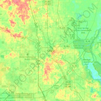
Name: Ocala topographic map, elevation, terrain.

Location: Ocala, Marion County, Florida, 34471:34474, United States (29.02720 -82.30009 29.34720 -81.98009)

Average elevation: 27 m

Minimum elevation: 5 m

Maximum elevation: 66 m

Other topographic maps

Click on a map to view its topography, its elevation and its terrain.

Lake Tuscawilla

United States > Florida > Marion County > Ocala

Average elevation: 31 m

Gear up for your next adventure:

🔪Outdoor Multi-Tools - Versatile tools for gear repairs and food prep in the wild
🔋Solar Power Banks - Keep your GPS and phone charged during multi-day expeditions
🗺️Ordnance Survey Maps - Essential paper maps for hiking across the UK national parks
🧥Waterproof Hiking Jackets - Rain protection for walking in all weather conditions
GPS Outdoor Watches - Watches with GPS tracking for hiking and exploration

As an Amazon Associate, this site earns from qualifying purchases at no extra cost to you.