Geolocate

Kenmore topographic map

Click on the map to display elevation.

About this map

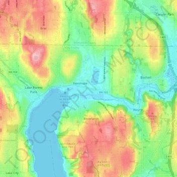
Name: Kenmore topographic map, elevation, terrain.

Location: Kenmore, King County, Washington, 98028, United States (47.71732 -122.28401 47.79732 -122.20401)

Average elevation: 68 m

Minimum elevation: -2 m

Maximum elevation: 171 m

Gear up for your next adventure:

❄️Walking Crampons - Added traction for icy slopes and winter peak bagging
👕Merino Base Layers - Natural temperature regulation for cold weather hiking and camping
🥼Base Layers - Thermal base layers for temperature regulation
🔦Head Torches - Hands-free lighting for hiking and camping
🥄Titanium Camping Sporks - The ultimate lightweight utensil for trail meals

As an Amazon Associate, this site earns from qualifying purchases at no extra cost to you.