
Belleville-en-Beaujolais topographic map
Interactive map
Click on the map to display elevation.
About this map
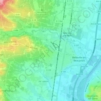
Name: Belleville-en-Beaujolais topographic map, elevation, terrain.
Average elevation: 189 m
Minimum elevation: 166 m
Maximum elevation: 244 m
Other topographic maps
Click on a map to view its topography, its elevation and its terrain.
Parc Popy
France > Auvergne-Rhône-Alpes > Rhône > Belleville-en-Beaujolais > Le Petit Quart
Parc Popy, La Ville-Est, Le Petit Quart, Belleville, Belleville-en-Beaujolais, Villefranche-sur-Saône, Rhône, Departemental constituency of Rhône, Auvergne-Rhône-Alpes, Metropolitan France, 69220, France
Average elevation: 179 m