
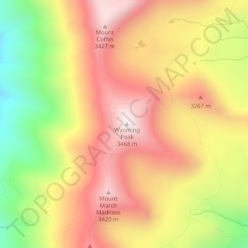
Wyoming Peak topographic map
Interactive map
Click on the map to display elevation.
About this map
Name: Wyoming Peak topographic map, elevation, terrain.
Location: Wyoming Peak, Lincoln County, Wyoming, United States (42.60428 -110.62390 42.60438 -110.62380)
Average elevation: 3,108 m
Minimum elevation: 2,667 m
Maximum elevation: 3,454 m
Other topographic maps
Click on a map to view its topography, its elevation and its terrain.
Afton
United States > Wyoming > Lincoln County
Afton, Lincoln County, Wyoming, 83110, United States
Average elevation: 2,001 m
Star Valley Ranch
United States > Wyoming > Lincoln County
Star Valley Ranch, Lincoln County, Wyoming, United States
Average elevation: 2,093 m
Wyoming Range
United States > Wyoming > Lincoln County
Wyoming Range, Lincoln County, Wyoming, United States
Average elevation: 2,357 m
Grover
United States > Wyoming > Lincoln County > Grover
Grover, Lincoln County, Wyoming, United States
Average elevation: 1,944 m
Kemmerer
United States > Wyoming > Lincoln County > Kemmerer
Kemmerer, Lincoln County, Wyoming, United States
Average elevation: 2,171 m
Alpine
United States > Wyoming > Lincoln County
Alpine, Lincoln County, Wyoming, 83128, United States
Average elevation: 1,748 m
Thayne
United States > Wyoming > Lincoln County > Thayne
Thayne, Lincoln County, Wyoming, United States
Average elevation: 1,814 m