Geolocate

South Alloa topographic map

Click on the map to display elevation.

About this map

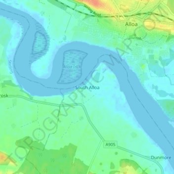
Name: South Alloa topographic map, elevation, terrain.

Location: South Alloa, Falkirk, Scotland, FK7 7LB, United Kingdom (56.08107 -3.83041 56.12107 -3.79041)

Average elevation: 8 m

Minimum elevation: -2 m

Maximum elevation: 37 m

Falkirk trails, hiking, mountain biking, running and outdoor activities

Gear up for your next adventure:

🔦Keychain LED Torches - Emergency backup light for finding gear in your pack
Lightweight Solo Tents - Backpacking tents designed for wild camping in the UK highlands
🗺️Ordnance Survey Maps - Essential paper maps for hiking across the UK national parks
🧤Hiking Gloves - Warm and durable gloves for cold-weather walks
🎒Multi-day Trekking Packs - Large capacity backpacks for wild camping and long-distance trails

As an Amazon Associate, this site earns from qualifying purchases at no extra cost to you.