
Yabelo topographic map
Interactive map
Click on the map to display elevation.
About this map
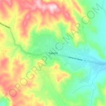
Name: Yabelo topographic map, elevation, terrain.
Location: Yabelo, Borena, Ethiopia (4.85257 38.05499 4.93257 38.13499)
Average elevation: 1,853 m
Minimum elevation: 1,627 m
Maximum elevation: 2,200 m
Yabelo (Oromo: Yaabeelloo) is a town in southern Ethiopia. An alternative name for this town is Obda, which is also the name of a nearby mountain. Located northwest of Moyale in the Borena Zone of the Oromia, this town has a latitude and longitude of 4°53′N 38°5′E / 4.883°N 38.083°E / 4.883; 38.083Coordinates: 4°53′N 38°5′E / 4.883°N 38.083°E / 4.883; 38.083 and an elevation of 1857 meters above sea level. It has been the administrative center of the Borena Zone since its division from Guji Zone in September 2002, as well as Yabelo woreda.