
Mitlödi topographic map
Interactive map
Click on the map to display elevation.
About this map
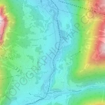
Name: Mitlödi topographic map, elevation, terrain.
Location: Mitlödi, Glarus Süd, Glarus, 8756, Switzerland (46.99147 9.05991 47.03147 9.09991)
Average elevation: 800 m
Minimum elevation: 481 m
Maximum elevation: 1,745 m
Mitlödi is located in the valley of the Linth river, on a pre-historic rock slide, at an elevation of 504 m (1,654 ft). It consists of the village of Mitlödi itself, and the separate section of Ennetlinth on the right bank of the Linth. The village of Schwanden lies upstream and to the south, whilst the town of Glarus is downstream and to the north.