
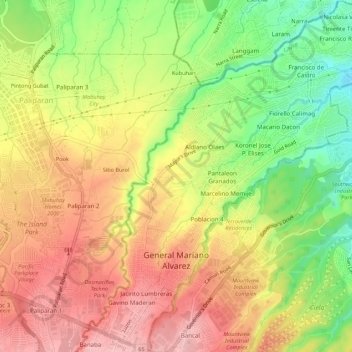
General Mariano Alvarez topographic map
Interactive map
Click on the map to display elevation.
About this map
Name: General Mariano Alvarez topographic map, elevation, terrain.
Average elevation: 128 m
Minimum elevation: 41 m
Maximum elevation: 199 m
Other topographic maps
Click on a map to view its topography, its elevation and its terrain.
Ayala Westgrove Heights
Philippines > Cavite > Puting Kahoy > Ayala Westgrove Heights
Average elevation: 161 m
Tagaytay
Philippines > Cavite > Tagaytay > Tagaytay
The southern and eastern portions of Tagaytay are covered by hills and mountains which is generally forests, pine trees and open grasslands. The city lies along Tagaytay Ridge, a ridge stretching about 32 kilometres (20 mi) from Mount Batulao in the west to Mount Sungay in the east with elevations averaging…
Average elevation: 229 m
Langkaan 2 (Humayao)
Philippines > Cavite > Dasmarinas > Langkaan 2 (Humayao)
Average elevation: 198 m
Precious Ville
Philippines > Cavite > Naic > Naic > Ibayo Estacion > Precious Ville
Average elevation: 10 m