
Buljarica topographic map
Interactive map
Click on the map to display elevation.
About this map
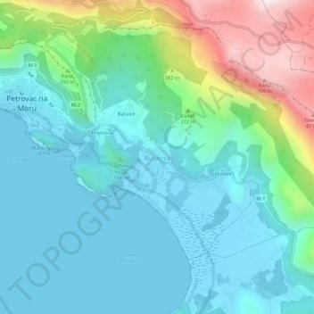
Name: Buljarica topographic map, elevation, terrain.
Location: Buljarica, Budva Municipality, Montenegro (42.17997 18.94526 42.21997 18.98526)
Average elevation: 173 m
Minimum elevation: -4 m
Maximum elevation: 757 m
Other topographic maps
Click on a map to view its topography, its elevation and its terrain.
View over the sea, mountain, and Buljarica beach
Montenegro > Budva Municipality > Buljarica > Bačvice
View over the sea, mountain, and Buljarica beach, M-1, Bačvice, Buljarica, Budva Municipality, Montenegro
Average elevation: 29 m