
Thank you for supporting this site ❤️
Make a donation
Make a donation
Gear up for your next adventure:
As an Amazon Associate, this site earns from qualifying purchases at no extra cost to you.
Piatra topographic map
Click on the map to display elevation.
Thank you for supporting this site ❤️
Make a donation
Make a donation
Gear up for your next adventure:
As an Amazon Associate, this site earns from qualifying purchases at no extra cost to you.
About this map
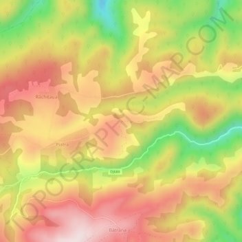
Name: Piatra topographic map, elevation, terrain.
Location: Piatra, Bătrâna, Hunedoara, 337072, Romania (45.78965 22.56635 45.82965 22.60635)
Average elevation: 752 m
Minimum elevation: 473 m
Maximum elevation: 961 m
Thank you for supporting this site ❤️
Make a donation
Make a donation
Gear up for your next adventure:
As an Amazon Associate, this site earns from qualifying purchases at no extra cost to you.