
Make a donation
Gear up for your next adventure:
As an Amazon Associate, this site earns from qualifying purchases at no extra cost to you.
Snellville topographic map
Click on the map to display elevation.
Make a donation
Gear up for your next adventure:
As an Amazon Associate, this site earns from qualifying purchases at no extra cost to you.
Snellville
Compared to most large cities around the world at approximately the same latitude (33°39'), such as Beirut, Casablanca, Dallas, Los Angeles, and Phoenix, Snellville has lower average winter temperatures. The primary reason for this is that the North American continent extends into high latitudes that allows systems to form and move eastward and southward without obstruction by major mountain ranges. Other factors include Snellville's distance from large bodies of water; its higher elevation, which can lead to rapid weather changes; prevailing wind patterns; and extensive tree cover, which reduces the urban heat island effect (an advantage during summer).
Make a donation
Gear up for your next adventure:
As an Amazon Associate, this site earns from qualifying purchases at no extra cost to you.
About this map
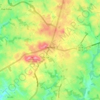
Name: Snellville topographic map, elevation, terrain.
Location: Snellville, Gwinnett County, Georgia, United States (33.81839 -84.04291 33.89217 -83.95093)
Average elevation: 300 m
Minimum elevation: 247 m
Maximum elevation: 363 m
Make a donation
Gear up for your next adventure:
As an Amazon Associate, this site earns from qualifying purchases at no extra cost to you.
Other topographic maps
Click on a map to view its topography, its elevation and its terrain.
Yellow River Post Office Site
United States > Georgia > Gwinnett County > Lilburn
Average elevation: 275 m
Make a donation
Gear up for your next adventure:
As an Amazon Associate, this site earns from qualifying purchases at no extra cost to you.
Pine Ridge Country Club Estates
United States > Georgia > Gwinnett County > Lawrenceville
Average elevation: 323 m
Make a donation
Gear up for your next adventure:
As an Amazon Associate, this site earns from qualifying purchases at no extra cost to you.