
Tazewell County topographic map
Interactive map
Click on the map to display elevation.
About this map
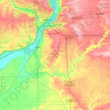
Name: Tazewell County topographic map, elevation, terrain.
Location: Tazewell County, Illinois, United States (40.31864 -89.92371 40.74827 -89.26375)
Average elevation: 190 m
Minimum elevation: 131 m
Maximum elevation: 259 m
Other topographic maps
Click on a map to view its topography, its elevation and its terrain.
Washington
United States > Illinois > Tazewell County
Washington, Tazewell County, Illinois, 61571, United States
Average elevation: 236 m
Deer Creek
United States > Illinois > Tazewell County
Deer Creek, Tazewell County, Illinois, United States
Average elevation: 227 m
Green Valley
United States > Illinois > Tazewell County
Green Valley, Tazewell County, Illinois, United States
Average elevation: 164 m
East Peoria
United States > Illinois > Tazewell County
East Peoria, Tazewell County, Illinois, 61611, United States
Average elevation: 176 m
Morton
United States > Illinois > Tazewell County
Morton, Tazewell County, Illinois, 61550, United States
Average elevation: 219 m