
修文县 topographic map
Interactive map
Click on the map to display elevation.
About this map
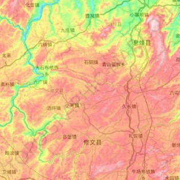
Name: 修文县 topographic map, elevation, terrain.
Location: 修文县, 贵阳市, 贵州省, 中国 (26.75433 106.35825 27.19579 106.87962)
Average elevation: 1,232 m
Minimum elevation: 740 m
Maximum elevation: 1,730 m
地处黔中丘陵盆地区,四分之三的地区为中丘陵区,岩溶地貌分布广泛,断层发育充分,地貌形态复杂多样。地势东高西低,较为平缓,西部边缘的六广河、猫跳河沿岸河谷深切。大部分地区在海拔1200~1400米之间,一般高差50~200米。主要山脉有牛项包、老将山、五老山、真武山、木阁菁、高峰山等。最高点位于三角山主峰,海拔1610米;最低点位于六广河出境处,海拔760米,相差850米。
Other topographic maps
Click on a map to view its topography, its elevation and its terrain.