
Stans topographic map
Click on the map to display elevation.
Stans
The area of Stans is 11.08 km2 (4.28 sq mi). Much of the land within the borders of Stans is agricultural (43.7%), while just over a third (36.5%) is forested. Of the remaining area, about 17% is settlements and less than 2.6% is unproductive (mountains, rivers or glaciers). The highest point within the borders of Stans is on the Stanserhorn and is 1,819 m (5,968 ft) above sea level. The lowest point is at Fronhofen where the elevation is 438 m (1,437 ft). The village square (Dorfplatz) has an elevation of 452 m (1,483 ft).
About this map
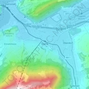
Name: Stans topographic map, elevation, terrain.
Location: Stans, Nidwalden, Switzerland (46.93129 8.34166 46.98193 8.38875)
Average elevation: 658 m
Minimum elevation: 432 m
Maximum elevation: 1,779 m