
Make a donation
Gear up for your next adventure:
As an Amazon Associate, this site earns from qualifying purchases at no extra cost to you.
New Tazewell topographic map
Click on the map to display elevation.
Make a donation
Gear up for your next adventure:
As an Amazon Associate, this site earns from qualifying purchases at no extra cost to you.
New Tazewell
When the railroad line was built from Knoxville through Cumberland Gap in the late 1880s, it bypassed the city of Tazewell. It is uncertain whether the railroad was unable to obtain right of way, or whether the decision was made because of topography, but the railroad depot was built about two miles to the west of Tazewell. A new community sprang up around the depot, called Cowan City on old survey maps. The city was incorporated as New Tazewell in the 1920s, but the charter was voted down about fifteen years later. It was reincorporated in 1954.
Make a donation
Gear up for your next adventure:
As an Amazon Associate, this site earns from qualifying purchases at no extra cost to you.
About this map
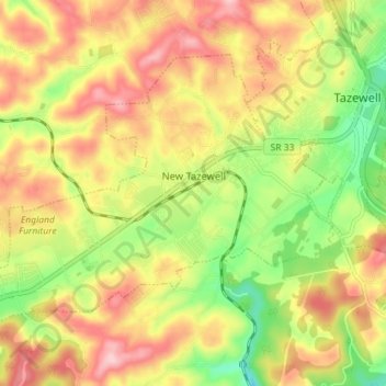
Name: New Tazewell topographic map, elevation, terrain.
Average elevation: 465 m
Minimum elevation: 360 m
Maximum elevation: 561 m
Make a donation
Gear up for your next adventure:
As an Amazon Associate, this site earns from qualifying purchases at no extra cost to you.
Other topographic maps
Click on a map to view its topography, its elevation and its terrain.
Make a donation
Gear up for your next adventure:
As an Amazon Associate, this site earns from qualifying purchases at no extra cost to you.