
Talmine topographic map
Interactive map
Click on the map to display elevation.
About this map
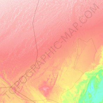
Name: Talmine topographic map, elevation, terrain.
Location: Talmine, Charouine District, Timimoune, Algeria (28.83645 -0.92035 29.75797 -0.31984)
Average elevation: 358 m
Minimum elevation: 170 m
Maximum elevation: 491 m
Talmine commune lies at an elevation of about 364 metres (1,194 ft). It covers the westernmost oases in the Gourara region of northern Adrar Province (excepting the villages of Meslila and Bent Cherk that lies in Béchar Province. The oases mainly lie in the southernmost part of the Grand Erg Occidental, a large area of sand dunes stretching well into Béchar and El Bayadh provinces.