
Cwm-nant-gwynt topographic map
Interactive map
Click on the map to display elevation.
About this map
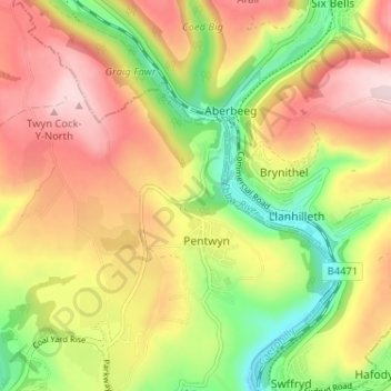
Name: Cwm-nant-gwynt topographic map, elevation, terrain.
Average elevation: 270 m
Minimum elevation: 122 m
Maximum elevation: 411 m
Other topographic maps
Click on a map to view its topography, its elevation and its terrain.
Nant Gwynt
United Kingdom > Wales > Caerphilly > Pentwyn > Cwm-nant-gwynt
Nant Gwynt, Cwm-nant-gwynt, Pentwyn, Crumlin, Caerphilly, Wales, NP13 2DQ, United Kingdom
Average elevation: 261 m