
Косаш topographic map
Interactive map
Click on the map to display elevation.
About this map
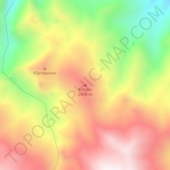
Name: Косаш topographic map, elevation, terrain.
Location: Косаш, Panjakent District, Sughd Region, Tajikistan (39.35997 67.88994 39.36007 67.89004)
Average elevation: 2,251 m
Minimum elevation: 1,761 m
Maximum elevation: 2,662 m
Other topographic maps
Click on a map to view its topography, its elevation and its terrain.
Panjakent
Tajikistan > Sughd Region > Panjakent District
Panjakent, Panjakent District, Sughd Region, 735500, Tajikistan
Average elevation: 1,035 m