
Thank you for supporting this site ❤️
Make a donation
Make a donation
Gear up for your next adventure:
As an Amazon Associate, this site earns from qualifying purchases at no extra cost to you.
Petergensfeld topographic map
Click on the map to display elevation.
Thank you for supporting this site ❤️
Make a donation
Make a donation
Gear up for your next adventure:
As an Amazon Associate, this site earns from qualifying purchases at no extra cost to you.
About this map
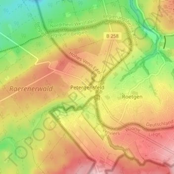
Name: Petergensfeld topographic map, elevation, terrain.
Location: Petergensfeld, Raeren, Verviers, Liège, Wallonie, Belgique (50.62928 6.16044 50.66928 6.20044)
Average elevation: 416 m
Minimum elevation: 328 m
Maximum elevation: 490 m
Thank you for supporting this site ❤️
Make a donation
Make a donation
Gear up for your next adventure:
As an Amazon Associate, this site earns from qualifying purchases at no extra cost to you.