
Ravenstruther topographic map
Interactive map
Click on the map to display elevation.
About this map
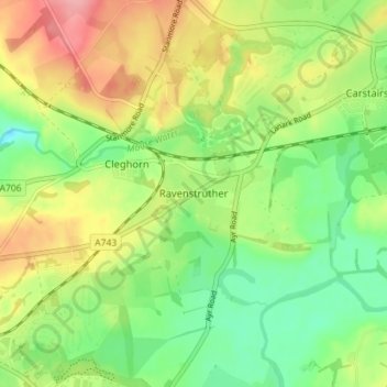
Name: Ravenstruther topographic map, elevation, terrain.
Average elevation: 212 m
Minimum elevation: 167 m
Maximum elevation: 271 m
South Lanarkshire trails, hiking, mountain biking, running and outdoor activities
Other topographic maps
Click on a map to view its topography, its elevation and its terrain.
Low Banks
United Kingdom > Scotland > South Lanarkshire > Lamington > Millhill
Average elevation: 263 m
Langlands Moss Local Nature Reserve
United Kingdom > Scotland > South Lanarkshire > East Kilbride
Average elevation: 204 m
Craignethan Castle
United Kingdom > Scotland > South Lanarkshire > Crossford > Tillietudlem
Average elevation: 121 m
Clyde Valley Family Park's Island
United Kingdom > Scotland > South Lanarkshire > Hazelbank > Birkhill
Average elevation: 119 m
Langlands Moss Lowland Raised Peatbog
United Kingdom > Scotland > South Lanarkshire > East Kilbride
Average elevation: 204 m
Trough Linn Woodlands Project
United Kingdom > Scotland > South Lanarkshire > East Kilbride
Average elevation: 185 m