
Brunn am Gebirge topographic map
Interactive map
Click on the map to display elevation.
About this map
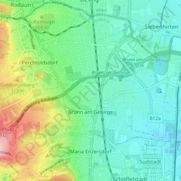
Name: Brunn am Gebirge topographic map, elevation, terrain.
Location: Brunn am Gebirge, Bezirk Mödling, Lower Austria, 2345, Austria (48.09917 16.24921 48.12541 16.31525)
Average elevation: 243 m
Minimum elevation: 194 m
Maximum elevation: 376 m
Other topographic maps
Click on a map to view its topography, its elevation and its terrain.
Vorderer Kaufberg
Austria > Lower Austria > Bezirk Mödling > Gemeinde Breitenfurt bei Wien
Average elevation: 341 m
Sulz im Wienerwald
Austria > Lower Austria > Bezirk Mödling > Gemeinde Wienerwald
Average elevation: 459 m