
Uwharrie topographic map
Interactive map
Click on the map to display elevation.
About this map
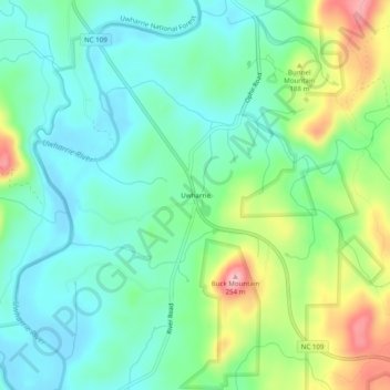
Name: Uwharrie topographic map, elevation, terrain.
Location: Uwharrie, Montgomery County, North Carolina, United States (35.39514 -80.02366 35.43514 -79.98366)
Average elevation: 141 m
Minimum elevation: 93 m
Maximum elevation: 252 m
Other topographic maps
Click on a map to view its topography, its elevation and its terrain.
Cul Res Town Creek Indian Mound
United States > North Carolina > Montgomery County
Average elevation: 71 m
Uwharrie National Forest
United States > North Carolina > Montgomery County > Troy
Average elevation: 175 m
Cul Res Town Creek Indian Mound
United States > North Carolina > Montgomery County
Average elevation: 71 m