
Make a donation
Gear up for your next adventure:
As an Amazon Associate, this site earns from qualifying purchases at no extra cost to you.
Byadagi topographic map
Click on the map to display elevation.
Make a donation
Gear up for your next adventure:
As an Amazon Associate, this site earns from qualifying purchases at no extra cost to you.
Byadagi
Byadgi is located at 14°41′N 75°29′E / 14.68°N 75.48°E / 14.68; 75.48. It has an average elevation of 601 meters (1971 feet).
Make a donation
Gear up for your next adventure:
As an Amazon Associate, this site earns from qualifying purchases at no extra cost to you.
About this map
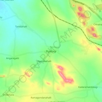
Name: Byadagi topographic map, elevation, terrain.
Location: Byadagi, Byadagi taluk, Haveri, Karnataka, 581106, India (14.63198 75.44582 14.71198 75.52582)
Average elevation: 620 m
Minimum elevation: 577 m
Maximum elevation: 696 m
Make a donation
Gear up for your next adventure:
As an Amazon Associate, this site earns from qualifying purchases at no extra cost to you.