
George topographic map
Interactive map
Click on the map to display elevation.
About this map
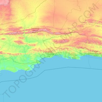
Name: George topographic map, elevation, terrain.
Location: George, Western Cape, South Africa (-34.43906 20.50315 -33.31496 23.70330)
Average elevation: 417 m
Minimum elevation: -1 m
Maximum elevation: 2,262 m
Other topographic maps
Click on a map to view its topography, its elevation and its terrain.
Cape Town
South Africa > Western Cape > City of Cape Town
The Cape Peninsula is 52 km long from Mouille Point in the north to Cape Point in the south, with an area of about 470 km2, and it displays more topographical variety than other similar sized areas in southern Africa, and consequently spectacular scenery. There are diverse low-nutrient soils, large rocky…
Average elevation: 53 m
Stellenbosch
South Africa > Western Cape > Cape Winelands District Municipality > Stellenbosch Local Municipality
Stellenbosch is 53 km (33 mi) east of Cape Town via National Route N1. Stellenbosch is in a hilly region of the Cape Winelands, and is sheltered in a valley at an average elevation of 136 m (446 ft), flanked on the west by Papegaaiberg (Afrikaans: Parrot Mountain), which is actually a hill. To the south is…
Average elevation: 287 m
Franschhoek
South Africa > Western Cape > Cape Winelands District Municipality > Stellenbosch Local Municipality
Average elevation: 502 m
Table Mountain
South Africa > Western Cape > City of Cape Town > Cape Town
Table Mountain is at the northern end of a sandstone mountain range that forms the spine of the Cape Peninsula that terminates approximately 50 kilometres (30 mi) to the south at the Cape of Good Hope and Cape Point. Immediately to the south of Table Mountain is a rugged "plateau" at a somewhat lower elevation…
Average elevation: 583 m
Durbanville
South Africa > Western Cape > City of Cape Town
Durbanville is situated in the northern suburbs of Cape Town, approximately 28 kilometres (17.4 mi) north-east of the city, bordered by Bellville to the south, Brackenfell to the south-east and Kraaifontein to the east. It lies at an altitude of between 100 m (328 ft) to 240 m (787 ft), in the vast rolling…
Average elevation: 157 m
Baviaanshoek
South Africa > Western Cape > Cape Winelands District Municipality > Witzenberg Local Municipality
Average elevation: 1,181 m
Tesselaarsdal
South Africa > Western Cape > Theewaterskloof Local Municipality
Average elevation: 273 m
Vredenburg
South Africa > Western Cape > West Coast District Municipality > Saldanha Bay Local Municipality
Average elevation: 91 m
Touws River
South Africa > Western Cape > Cape Winelands District Municipality > Breede Valley Local Municipality
Touws River is located at an elevation of 770 metres (2,530 ft) on the southwestern edge of the Great Karoo, east of the Hex River Mountains and north of the Langeberg, at the point where the Donkeys River flows into the Touws River. It lies just to the south of the N1 highway, 180 kilometres (110 mi) by road…
Average elevation: 822 m
Matjiesfontein
South Africa > Western Cape > Central Karoo District Municipality > Laingsburg Local Municipality
Average elevation: 972 m
Dassen Island
South Africa > Western Cape > West Coast District Municipality > Swartland Local Municipality
Average elevation: 2 m
Mossel Bay
South Africa > Western Cape > George
To the east, the land slopes upwards towards the wave-cut platform (average elevation 245 metres) that characterises the more lush all-year-round rainfall area of the Garden Route. Here the land is mostly covered by grass and farmlands. The deep sandy soils of the western portion of the municipal area also…
Average elevation: 16 m
Darling Wildflower Nature Reserve
South Africa > Western Cape > West Coast District Municipality > Swartland Local Municipality > Darling
Average elevation: 148 m
Koekenaap
South Africa > Western Cape > West Coast District Municipality > Matzikama Local Municipality
Average elevation: 46 m
Wemmershoek Dam
South Africa > Western Cape > Cape Winelands District Municipality > Paarl
Average elevation: 396 m
Cape Fold Mountains
South Africa > Western Cape > Central Karoo District Municipality > Prince Albert Local Municipality
The degree to which the original Cape Fold mountains (formed during the Carboniferous and early Permian Periods) have been eroded is attested to by the fact that the 1 km high Table Mountain on the Cape Peninsula is a syncline mountain, meaning that it formed part of the bottom of a valley when the Cape…
Average elevation: 1,419 m
Loskop
South Africa > Western Cape > Cape Winelands District Municipality > Breede Valley Local Municipality
Average elevation: 561 m
Beaufort West
South Africa > Western Cape > Central Karoo District Municipality > Beaufort West Local Municipality
Average elevation: 854 m
Chaos
South Africa > Western Cape > Cape Winelands District Municipality > Witzenberg Local Municipality
Average elevation: 1,346 m
Hex River
South Africa > Western Cape > Cape Winelands District Municipality > Breede Valley Local Municipality
Average elevation: 644 m
Mossel Bay
South Africa > Western Cape > George
To the east, the land slopes upwards towards the wave-cut platform (average elevation 245 metres) that characterises the more lush all-year-round rainfall area of the Garden Route. Here the land is mostly covered by grass and farmlands. The deep sandy soils of the western portion of the municipal area also…
Average elevation: 16 m
Table Mountain
South Africa > Western Cape > City of Cape Town > Cape Town
Table Mountain is at the northern end of a sandstone mountain range that forms the spine of the Cape Peninsula that terminates approximately 50 kilometres (30 mi) to the south at the Cape of Good Hope and Cape Point. Immediately to the south of Table Mountain is a rugged "plateau" at a somewhat lower elevation…
Average elevation: 578 m
Piketberg
South Africa > Western Cape > West Coast District Municipality > Bergrivier Local Municipality
Average elevation: 265 m
Krom
South Africa > Western Cape > West Coast District Municipality > Cederberg Local Municipality
Average elevation: 870 m
Tafelberg
South Africa > Western Cape > Cape Winelands District Municipality > Breede Valley Local Municipality
Average elevation: 946 m
Klawer
South Africa > Western Cape > West Coast District Municipality > Matzikama Local Municipality
Average elevation: 142 m
Vredendal
South Africa > Western Cape > West Coast District Municipality > Matzikama Local Municipality
Average elevation: 51 m
Wolfberg Arch
South Africa > Western Cape > West Coast District Municipality > Cederberg Local Municipality > Cederberg
Average elevation: 1,413 m
Lambert's Bay
South Africa > Western Cape > West Coast District Municipality > Cederberg Local Municipality
Average elevation: 19 m
Uitkyk
South Africa > Western Cape > West Coast District Municipality > Matzikama Local Municipality
Average elevation: 54 m
Klaarstroom
South Africa > Western Cape > Central Karoo District Municipality > Prince Albert Local Municipality
Average elevation: 775 m
Pringle Bay
South Africa > Western Cape > Overberg District Municipality > Overstrand Local Municipality
Average elevation: 62 m
Cape Town
South Africa > Western Cape > City of Cape Town
The Cape Peninsula is 52 km (30 mi) long from Mouille Point in the north to Cape Point in the south, with an area of about 470 km2 (180 sq mi), and it displays more topographical variety than other similar sized areas in southern Africa, and consequently spectacular scenery. There are diverse low-nutrient…
Average elevation: 53 m
Worcester
South Africa > Western Cape > Cape Winelands District Municipality > Breede Valley Local Municipality
Worcester is located at an elevation of 220 metres (720 ft) and can be reached by road either travelling on the N1 highway through the Huguenot Tunnel or by driving through spectacular mountain passes. From Cape Town Du Toitskloof, from Wellington Bainskloof, from Malmesbury, Western Cape Nieuwekloof, from…
Average elevation: 252 m
Ashton
South Africa > Western Cape > Cape Winelands District Municipality > Langeberg Local Municipality
Average elevation: 243 m
Cathkin Park
South Africa > Western Cape > City of Cape Town > Mitchells Plain
Average elevation: 15 m
Clanwilliam
South Africa > Western Cape > West Coast District Municipality > Cederberg Local Municipality
Clanwilliam is situated at an elevation of 100 metres (330 ft), between the western slopes of the Cederberg mountains and the east bank of the Olifants River, which is impounded there by the Clanwilliam Dam. It lies just off the N7 national road, which runs from Cape Town to the Namibian border, and on the…
Average elevation: 162 m
Saldanha
South Africa > Western Cape > West Coast District Municipality > Saldanha Bay Local Municipality
Average elevation: 27 m
Strandfontein
South Africa > Western Cape > West Coast District Municipality > Matzikama Local Municipality
Average elevation: 36 m
Ceres
South Africa > Western Cape > Cape Winelands District Municipality > Witzenberg Local Municipality
Ceres experiences a typical Mediterranean climate tempered by its altitude. The town experiences warmer temperatures in summer, due to its inland location with infrequent rainfall, however winters are cool to quite cold and wet, with frequent snowfalls on the surrounding higher-lying ground, rarely falling on…
Average elevation: 586 m
Darling
South Africa > Western Cape > West Coast District Municipality > Swartland Local Municipality
Average elevation: 156 m
Cape Town
South Africa > Western Cape > City of Cape Town
The Cape Peninsula is 52 km (30 mi) long from Mouille Point in the north to Cape Point in the south, with an area of about 470 km2 (180 sq mi), and it displays more topographical variety than other similar sized areas in southern Africa, and consequently spectacular scenery. There are diverse low-nutrient…
Average elevation: 53 m