
Thank you for supporting this site ❤️
Make a donation
Make a donation
Gear up for your next adventure:
As an Amazon Associate, this site earns from qualifying purchases at no extra cost to you.
Sululta topographic map
Click on the map to display elevation.
Thank you for supporting this site ❤️
Make a donation
Make a donation
Gear up for your next adventure:
As an Amazon Associate, this site earns from qualifying purchases at no extra cost to you.
About this map
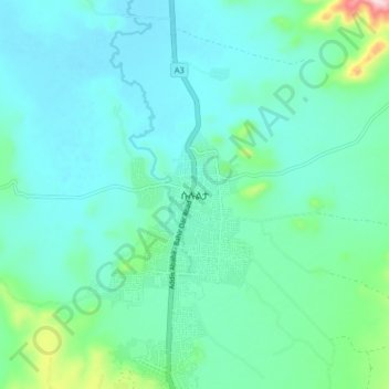
Name: Sululta topographic map, elevation, terrain.
Location: Sululta, North Shewa (Oromia Region), Oromia Region, Ethiopia (9.14126 38.71938 9.22126 38.79938)
Average elevation: 2,606 m
Minimum elevation: 2,549 m
Maximum elevation: 2,881 m
Thank you for supporting this site ❤️
Make a donation
Make a donation
Gear up for your next adventure:
As an Amazon Associate, this site earns from qualifying purchases at no extra cost to you.