Geolocate

Ocampo topographic map

Interactive map

Click on the map to display elevation.

About this map

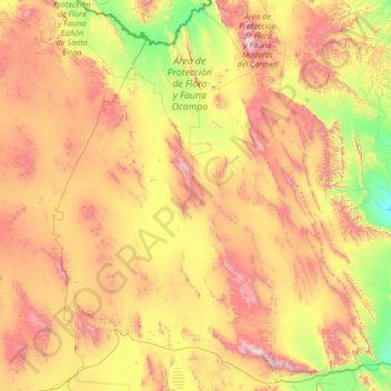
Name: Ocampo topographic map, elevation, terrain.

Location: Ocampo, Coahuila, Mexico (26.87313 -103.63750 29.24046 -101.89345)

Average elevation: 1,250 m

Minimum elevation: 471 m

Maximum elevation: 2,860 m

Other topographic maps

Click on a map to view its topography, its elevation and its terrain.

Colonia Venustiano Carranza

Mexico > Coahuila > Nava

Average elevation: 265 m

Ciudad Acuña

Mexico > Coahuila > Acuña

Average elevation: 325 m

Solima

Mexico > Coahuila > Matamoros

Average elevation: 1,114 m

Parras

Mexico > Coahuila

Average elevation: 1,412 m

Saltillo

Mexico > Coahuila > Saltillo

El Cerro del Pueblo (The People's Hill) and its 4-metre (13 ft) cross overlook the city. The city's elevation makes it colder and windier than the neighboring city of Monterrey. Saltillo lies in the Chihuahuan Desert near the city of Arteaga. The city is flanked by the Zapalinamé mountains, which are part of…

Average elevation: 1,857 m

Torreón

Mexico > Coahuila > Torreón

Average elevation: 1,166 m

Loma Bola

Mexico > Coahuila > Ramos Arizpe > Paredón

Average elevation: 776 m

Piedras Negras

Mexico > Coahuila > Piedras Negras

Average elevation: 236 m

Monclova

Mexico > Coahuila > Monclova

Average elevation: 758 m