Geolocate

Portel topographic map

Interactive map

Click on the map to display elevation.

About this map

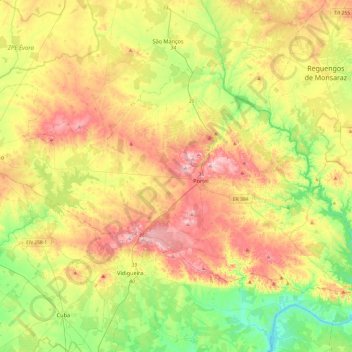
Name: Portel topographic map, elevation, terrain.

Location: Portel, Évora, Portugal (38.18845 -7.93649 38.43860 -7.45699)

Average elevation: 216 m

Minimum elevation: 70 m

Maximum elevation: 409 m

Other topographic maps

Click on a map to view its topography, its elevation and its terrain.

Alqueva

Portugal > Évora > Amieira e Alqueva

Average elevation: 191 m

Monte do Trigo

Portugal > Évora

Average elevation: 230 m

Nossa Senhora de Machede

Portugal > Évora > Évora

Average elevation: 232 m

Ciborro

Portugal > Évora > Montemor-o-Novo

Average elevation: 172 m

Cabrela

Portugal > Évora > Montemor-o-Novo

Average elevation: 110 m

Terena

Portugal > Évora > Terena (São Pedro)

Average elevation: 191 m

Reguengos de Monsaraz

Portugal > Évora

Average elevation: 207 m

Évora

Portugal > Évora

Évora (altitude 300m) is situated in Alentejo, a large region of wide plains in the south of Portugal, bordered to the North by the Tagus River and to the South by the region of Algarve. The city is 140 km (87 mi) from the capital city Lisbon, and 80 km (50 mi) from Badajoz at the Spanish border. It is the…

Average elevation: 247 m

Vendas Novas

Portugal > Évora

Average elevation: 122 m

Estremoz

Portugal > Évora > Estremoz

Average elevation: 310 m

Monsaraz

Portugal > Évora > Monsaraz

Average elevation: 182 m

Redondo

Portugal > Évora > Redondo > Redondo

Average elevation: 270 m

Ribeira de Cabrela

Portugal > Évora > Cabrela

Average elevation: 76 m

Évora Monte

Portugal > Évora > Évora Monte > Évora Monte

Average elevation: 325 m

Arraiolos

Portugal > Évora > Arraiolos > Arraiolos

Average elevation: 287 m

Borba

Portugal > Évora > Borba

Average elevation: 347 m

Évora

Portugal > Évora > Évora

Average elevation: 254 m

Arraiolos

Portugal > Évora

Average elevation: 228 m

Estremoz

Portugal > Évora

Average elevation: 308 m

Redondo

Portugal > Évora

Average elevation: 267 m