
Koyilandy topographic map
Interactive map
Click on the map to display elevation.
Koyilandy
Koyilandy is located at 11°26′N 75°42′E / 11.43°N 75.70°E / 11.43; 75.70 at an average elevation of 2 m (6.6 ft).
About this map
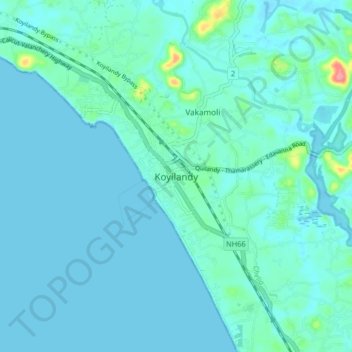
Name: Koyilandy topographic map, elevation, terrain.
Average elevation: 9 m
Minimum elevation: -2 m
Maximum elevation: 84 m
Other topographic maps
Click on a map to view its topography, its elevation and its terrain.
Kinaloor Chitra Mangalam Kshethra Kulam
India > Kerala > Koyilandi > vattoli bazar
Average elevation: 32 m