
Handcross topographic map
Click on the map to display elevation.
About this map
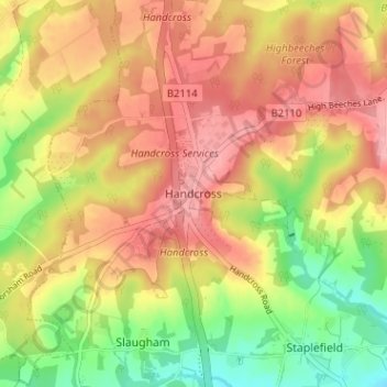
Name: Handcross topographic map, elevation, terrain.
Average elevation: 112 m
Minimum elevation: 53 m
Maximum elevation: 157 m
West Sussex trails, hiking, mountain biking, running and outdoor activities
Other topographic maps
Click on a map to view its topography, its elevation and its terrain.
Ardingly Reservoir
United Kingdom > England > West Sussex > Mid Sussex > Ardingly
Average elevation: 98 m
Cock Robin Wood
United Kingdom > England > West Sussex > Mid Sussex > East Grinstead > Saint Hill Green
Average elevation: 103 m