Geolocate

Zapala topographic map

Interactive map

Click on the map to display elevation.

About this map

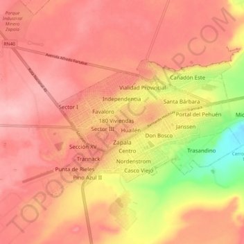
Name: Zapala topographic map, elevation, terrain.

Location: Zapala, Municipio de Zapala, Departamento Zapala, Neuquén Province, Q8340, Argentina (-38.91347 -70.09164 -38.87608 -69.99993)

Average elevation: 1,030 m

Minimum elevation: 933 m

Maximum elevation: 1,074 m

Other topographic maps

Click on a map to view its topography, its elevation and its terrain.

La Rinconada

Argentina > Neuquén Province

Average elevation: 765 m

Neuquén

Argentina > Neuquén Province

Average elevation: 289 m

Municipio de Villa La Angostura

Argentina > Neuquén Province

The elevation of the city centre is about 790 m (2,590 ft), and the lake is at 765 m (2,510 ft). Surrounding mountains range from 1,500 m (4,900 ft) to about 2,000 m (6,600 ft) (Cerro Bayo, right behind the city, is 1,782 m (5,846 ft) high).

Average elevation: 1,037 m

Cerro Whimper

Argentina > Neuquén Province

Average elevation: 1,345 m

Cerro Inacayal

Argentina > Neuquén Province

Average elevation: 1,546 m

Don Antonio

Argentina > Neuquén Province > Plottier

Average elevation: 278 m

Chos Malal

Argentina > Neuquén Province > Chos Malal

Average elevation: 894 m

Villa La Angostura

Argentina > Neuquén Province

The elevation of the city centre is about 790 m (2,590 ft), and the lake is at 765 m (2,510 ft). Surrounding mountains range from 1,500 m (4,900 ft) to about 2,000 m (6,600 ft) (Cerro Bayo, right behind the city, is 1,782 m (5,846 ft) high).

Average elevation: 921 m

Copahue

Argentina > Neuquén Province

Average elevation: 2,646 m