
Croagh topographic map
Interactive map
Click on the map to display elevation.
About this map
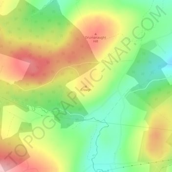
Name: Croagh topographic map, elevation, terrain.
Location: Croagh, Letterkenny, County Donegal, Ireland (54.90025 -7.83833 54.90035 -7.83823)
Average elevation: 241 m
Minimum elevation: 160 m
Maximum elevation: 332 m
Other topographic maps
Click on a map to view its topography, its elevation and its terrain.
Lough Salt
Lough Salt, Glen ED, Letterkenny, County Donegal, Ireland
Average elevation: 246 m
Balleeghan
Balleeghan, Manorcunningham Electoral Division, Letterkenny, County Donegal, Ireland
Average elevation: 42 m