
Trelawny topographic map
Interactive map
Click on the map to display elevation.
About this map
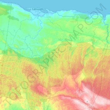
Name: Trelawny topographic map, elevation, terrain.
Location: Trelawny, Cornwall County, Jamaika (18.20980 -77.77569 18.51155 -77.44182)
Average elevation: 325 m
Minimum elevation: -1 m
Maximum elevation: 979 m
Other topographic maps
Click on a map to view its topography, its elevation and its terrain.
Green Hill
Green Hill, Saint Elizabeth, Cornwall County, Jamaika
Average elevation: 476 m
Richmond Vale
Richmond Vale, Saint Thomas, Surrey County, Jamaika
Average elevation: 633 m
Cotswold Hill
Cotswold Hill, Saint Catherine, Middlesex County, Jamaika
Average elevation: 514 m
Round Hill
Jamaika > Malvern > Round Hill
Round Hill, Malvern, Saint Elizabeth, Cornwall County, Jamaika
Average elevation: 207 m
Four Paths
Four Paths, Clarendon, Middlesex County, Jamaika
Average elevation: 50 m
Perseverance
Perseverance, Saint Ann, Middlesex County, Jamaika
Average elevation: 574 m