Geolocate

Balty topographic map

Click on the map to display elevation.

About this map

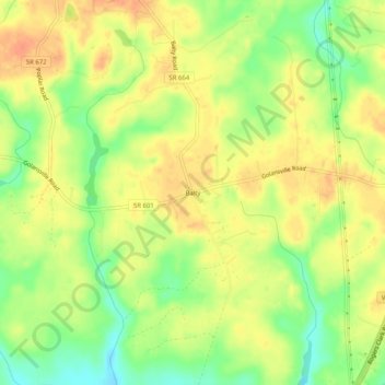
Name: Balty topographic map, elevation, terrain.

Location: Balty, Caroline County, Virginia, 22501, United States (37.97764 -77.46498 38.01764 -77.42498)

Average elevation: 61 m

Minimum elevation: 36 m

Maximum elevation: 77 m

Other topographic maps

Click on a map to view its topography, its elevation and its terrain.

Gear up for your next adventure:

🗺️Ordnance Survey Maps - Essential paper maps for hiking across the UK national parks
🥾Women's Waterproof Hiking Boots - High-performance trekking boots designed for all-weather comfort
🥤Collapsible Water Bottles - Save space in your rucksack as you consume your water
🐕Dog Hiking Gear - Equipment for hiking safely with dogs
🧤Thermal Touchscreen Gloves - Stay warm while operating your GPS or smartphone camera

As an Amazon Associate, this site earns from qualifying purchases at no extra cost to you.