
Make a donation
Gear up for your next adventure:
As an Amazon Associate, this site earns from qualifying purchases at no extra cost to you.
Easter Island topographic map
Click on the map to display elevation.
Make a donation
Gear up for your next adventure:
As an Amazon Associate, this site earns from qualifying purchases at no extra cost to you.
Easter Island
The current Polynesian name of the island, Rapa Nui ("Big Rapa"), was coined after the slave raids of the early 1860s, and refers to the island's topographic resemblance to the island of Rapa in the Bass Islands of the Austral Islands group. However, Norwegian ethnographer Thor Heyerdahl argued that Rapa was the original name of Easter Island and that Rapa Iti was named by refugees from there.
Make a donation
Gear up for your next adventure:
As an Amazon Associate, this site earns from qualifying purchases at no extra cost to you.
About this map
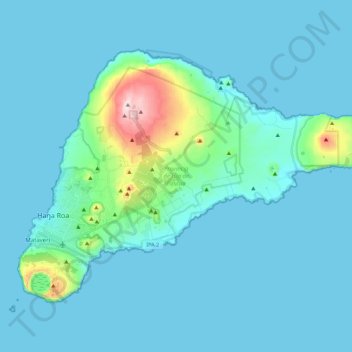
Name: Easter Island topographic map, elevation, terrain.
Average elevation: 48 m
Minimum elevation: 0 m
Maximum elevation: 506 m
Make a donation
Gear up for your next adventure:
As an Amazon Associate, this site earns from qualifying purchases at no extra cost to you.
Other topographic maps
Click on a map to view its topography, its elevation and its terrain.
Ma'uŋa Te Hoŋa (O Koro)
Chile > Valparaiso Region > Easter Island Province > Easter Island
Average elevation: 255 m
Punta Roa
Chile > Valparaiso Region > Easter Island Province > Easter Island > Hanga Roa
Average elevation: 11 m
Terevaka
Chile > Valparaiso Region > Easter Island Province > Easter Island
Terevaka is the 12th most topographically isolated summit on Earth.
Average elevation: 384 m
Make a donation
Gear up for your next adventure:
As an Amazon Associate, this site earns from qualifying purchases at no extra cost to you.